Wednesday, December 31, 2014

A cold finale hike of 2014


There couldn't have been a better day to have taken to the Downs and put the group through an endurance hike. On a crisp, frozen, sunny, blue sky morning, the 6 strong troupe assembled at 9.30am and took to striding through the groups of mainly dogwalkers and off road cyclist towards Beachy Head from Butts Brow. The sun was in our eyes and the terrain was hardened by the sub zero temperature. We were soon generating heat from our swinging limbs and with dogs accompanying us today, they were soon making light of the occasion by going in different directions.
We soon gathered them and indicated our direction and were able to maintain interest and as much pace as we were for the first mile. We reached the first dew pond which was frozen however not strong enough to take our weight. Not even the dogs were interested in the idea of a skating lesson.
The golf course soon after, was sparsely occupied as we dodged aside to allow more cyclist go through in the opposite direction. We reached the junction of footpaths that left us pondering whether we could manage a little further distance or head down through our more relied route through more of the golf course.
We decided on continuing towards Beachy Head a little further and then cut across another footpath to drop down into East Dean.
We crossed the main coastal road between Eastbourne and Seaford and reached the second Dew Pond which again was half covered in thick sheets of ice. The dogs were again intrigued to find ice and whilst one was more attracted to the idea of bathing, the other looked on with no interest to wallow.
We continued and crossed the road leading out of Old Town area of Eastbourne. The sun continued to shine bright and low in the sky and the ground showed little evidence of it ever thawing today.
The small camp site on our right had a few festive camper vans pitched in for the duration and would likely be seeing the new year in tomorrow evening from their vantage point which gave views across the bay toward Hastings.
We needed to walk briefly alongside the road before heading back across the Downs onto a Bridlepath known as 'Long Down'. We walked passed fields of sheep. In fact we disturbed a Ram that was resting next to the flint wall after perhaps some early morning 'tupping'. The flock had appeared to have devoured a field of Brussels sprouts... unless the farmer had removed the Brussels and left the stalks for them to finish off before cutting them down. Our journey toward Belle Tout lighthouse was straight and after walking passed a herd of cattle feeding hay from galvanized hoppers we spotted a rather large bloated brown cow laying on its side showing no signs of life, even after one of the dogs went to investigate. It was evident that the farmer hadn't stock checked for a few days and had left the cattle to fend for themselves. The mood quietened for a short while as it was clearly a distressing scene to observe to an otherwise healthy looking herd.
A steady walk down into East Dean, however one of our fold was starting to suffer with an ongoing complaint of plantar fasciitis, which meant that the final few miles would be impossible for him to complete. He'd phoned to request his wife meet him opposite the Tiger Inn whilst we took a break and refueled with flasks and mince pies! at the 6 mile point.
We were now 1 man down and ready to do justice to the final stretch uphill toward the junction that would eventually lead us to the Old Willingdon Road. A route which was a regular return to Butts Brow, but one which always had to be negotiated with more cyclists and walkers out for their post Christmas exercise.
As we looked behind, the sun was beaming down pools of light onto the sea and the fields of winter greens were abundant with growth for the livestock that were likely to need sustenance over the coming months.
Our walk was completed as we walked down toward the car park and the time was 1.30pm. The dogs had to be rounded up whilst we had little hesitation in unlacing our boots and collapsing into the cars after completing 9.5 miles

Thursday, December 18, 2014

A Christmas Trail (around Isfield)

The logistics on paper appeared to work out for us. The usual 6 suspects would meet at the Laughing Fish at 10am, then walk a pre-planned route (courtesy of an Argos walk published in July 2012), then back to the pub for a Christmas meal after what looked like an achievable 5¼ mile walk in just over 2 hours. Without our usual refreshment break, it seemed the perfect days activity.
What we hadn't bargained for was the the underfoot conditions and the lack of signposting which had us disorientated soon after we'd departed the pub and reaching the first stile.


Looking around and reading the directions we didn't pick out any of the described landmarks. Some instinctive treading along worn walkways in the field led us to one gate and then eventually another stile. It wasn't looking good as we failed to maintain good purchase on the slippery muddy fields.
Heading towards a farm which we thought would lead us out onto the main road was in our sights after crossing fields that had been cordoned off with temporary electric fences that had been organised to allow horses to have their right to roam over our rights.

"Can I help you?"... a lady came from the barn walked towards us. Her manner was pleasant however she informed us that the way along the drive to the road wasn't a 'right of way' and that the owner of the land would be none to pleased about us walking through this route. She advised us of the alternative route, which meant re-tracing our slippery steps in the same few fields.
The toil of walking on this surface was beginning to tell on us and realised there might be difficulty in keeping on track. 

Time was precious and our chances of continuing on the same route to walk across the National Golf course was fading fast. We consulted the OS map and decided on an alternative route that would take us further north yet still encounter the Lavender Line, which was part of the original route.
We found our way across some more fields and eventually out onto the A26 where the convenience of a footpath was a pleasant relief to walk on.

We soon turned off onto a lane with the golf course on our right and Wharton Wood on our left. It wasn't long before we were treading across another field where we'd eventually discover the welcome sight of the Railway line which ran between Isfield and a halt affectionately referred to as Dingly Dell (on the OS map).

But although the railway line was in sight, the challenge to find the crossing point left us concerned about the lack of signposting, but we eventually found it and stopped to observe 3 roe deer attempting to find a way out from the confines of the railway line.


The final phase of the walk would take us through treacherous conditions and that the addition of snorkels in our equipment might have been a good idea. We were about to walk alongside the banks of the Rivere Uck which was swelling and flowing fast.

"This way looks better" every man to his own route seemed to be the optional strategy. Puddles of muddy water were ankle deep and creeping into our boots!!
Horses looked on with bemused wonderment as we made our way through barricaded gateways. Someone was making it difficult for us, even though the green dotted lines on the OS map and the few footpath signs gave us clues that we were on a legitimate route.

Another 10 minutes and we had reached Elms Farm and walked through despite signs that suggested we may have been trespassing.

The Isfield sign welcomed us back into the village and the sight of the pub came into view. It was coming up to midday and after 3.5 miles we had disrobed in the car park and ready to take up our places at the reserved table to consume a tasty Christmas meal....

We spent the afternoon around the table reflecting on the year's walking and all agreed the amazing walks we'd achieved although also considered that the last couple of hours wouldn't necessarily feature as one of the highlighted walks. We will now be taking a couple weeks off and plan some more interesting and maybe adventurous walks for 2015.

Friday, December 12, 2014

A Bridge too Far (Polegate Wetland Trail)

We should have taken more notice of the small print on the Wealden Walk guide sheet.
"CAUTION - The route east of the Cuckoo Trail crosses a wetland area and may be flooded following wet weather"
Most walks at this time of year could have this added to it, however our need to take to the fields in the surrounding fields between Hailsham and Polegate appeared to be a worthwhile venture.
But not all was as easy as we'd planned. We arrived around 9.20 at our rendezvous point at the Old Loom Mill car park on the Ersham Road.We found the access gate to the Cuckoo Trail was locked with a sign indicating that it would be opened at 10.00am.
We discovered that the lady who runs the fabric Dept in the Loom held the key and would be arriving shortly by bus and her first task of the morning was to open the gate. We stood and waited her arriving wondering what to do if her bus was held up behind a convoy of buses and what their contingency plan was if she phoned in sick for the day. Our hike plans were in jeopardy.
But wait, here she came. Strolling up the drive and as promised her first task of the day was to make a B line to the gate and unlock the gate.

We exchanged morning greetings with her as she headed back to her fabrics whilst we escaped the compound and headed north on the Cuckoo Trail.

The sun was shining bright and the wind on our back as we got into our stride along the path toward the pelican crossing and onwards towards Hailsham. But it wasn't long after crossing the road before we headed across the first series of fields divided by stiles of varying heights and state of repair.
We trudged our way along the Saltmarsh Lane (that was the clue of the state of the fields we were about to cross) after spying on a barn full of vegetables that were being boxed up and transported by white vans to local markets and shops.

The traffic along the lane was relatively busy as over recent years has become a short-cut into the centre of Hailsham. We were thankful to be escaping over the roadside stile after a 5 minute walk along this lane and once again finding our way across a sequence of stiles and fields and a short wooded area which then had us entering a field of Shetland Ponies that were inquisitive at first. Once getting out of the field one of the ponies suddenly galloped at full throttle the length of the field and we were pleased they hadn't displayed such activity as we entered the field. We threaded our way around Little Downash Farm which was surrounded by fields of horses of varying sizes and started to discover more moisture in the sequence of fields that followed. Sheep as well as horses looked at the 4 of us attempted to find the driest route across the marshy fields. 


We stopped and confirmed our position as the lack of signposts gave an impression that although there were dotted green lines on the OS map, there were no indication that we were on the right track.
As we traversed the swamplands a fox scampered across the field ahead of us. It seemed intent on finding the nearest hiding place.


A bridge across a stream located our position and assumed our route across it although still faltered on the opposite side for a few minutes but retraced our muddy foot tracks and walked alongside the next ditch. Almost by accident, we discovered a signposted gap in the hedge and small wooden bridge which enabled our walk to continue toward Decoy Wood. Once again the driest route eluded us to some extent, whilst we excited a herd of cattle who probably thought we had food for them. Thankfully their stampede toward us was hindered by a few ditches of water between them and us, which distracted their willingness to cross and therefore allow us to reach the gate and then into the wood. There was a momentary stand-off as we were in the same field as the cattle and noted the bull amongst them was ready to assert his authority in front of his pose.

We were soon trekking our way through part of the grounds of Glyndley Manor which eventually came out onto Glynleigh Road which was the local access road to Hankham. We were only on it a few minutes as the route took us down the driveway to Priesthawes Farm where a collection of barns and outbuildings were occupied by different businesses. Chafins had their winter stock of logs ready after a summer of tree surgery work and a Barn full of red double decker buses were in hibernation ready for next years 'hop on - hop off' sightseeing tours of the Eastbourne area.

More fields of horses lined the driveway as we continued through the farm passing by the Priesthawes House. At the end of the drive were 2 large metal posts upon which was mounted a drill head. We crossed the main road and went directly opposite down towards the Polegate Bypass. Our powers of navigation left us bemused as although the OS map indicated the direction in which we needed to walk in order to reach the footbridge that crossed the bypass, we seemed to be led into a corner of a field with no escape. We walked a short distance to find a gateway onto Shepham Lane.


A chance to kick some mud from out boots as we walked the lane and find our bearings and see whereabouts the footpath would have been marked around the small reservoir of water in the field to our left. 
The sound of the traffic on the By-Pass was growing louder and we crossed the bridge to find a convenient place to sit for a short while and re-hydrate our thirst from our silver flasks.

We debated the options on which route  to take us back toward the Cuckoo Trail and the final approx.1½ miles northwards trek from where we'd joined the Trail.
We decided on what at first looked to be both quicker and less muddy path. Little did we think our final gateway would be totally awash with thick deep mud. 
The foot bridge that would take us back to the Old Loom appeared as we turned right onto the Cuckoo Trail. on the opposite side a couple horses were coming toward us, but turned down to the left as we reached them as it was feared that the width of the bridge would struggle to entertain us walking four abreast as well as 2 horses and riders.


The growing number of benches with memorial plaques adorned the final stretch of the Cuckoo Trail. No time for us to sit and watch the wildlife now, even though the notice board offered us useful information to identify anything that should pass us by.

Dodging the occasional cyclist we reached the car park without further hindrance unscathed. The gates were still open thankfully and ready to release the laces from our boots after our walk of 5.8 miles.

Friday, November 28, 2014

Muddy Trail around Herstmonceux Castle

There were only four of us out today. We parked on the muddy verge outside Herstmonceux Church and laced up boots and strapped on back packs to head off to find the 1066 route, at the very end of Church Lane. The gateway was entirely flooded, and would not be the last we saw of flooded lanes during the days walk. 


The view across the Pevensey Levels towards Hailsham and the South Downs beyond in the misty distance gave an encouraging feel for the day, however our well shone boots were soon muddied as we crossed through the Science Centre of Herstmonceux Castle and traversed our way downwards along a very muddy track. The gate at the bottom opened out into a field where the sight of one of the large telescope domes stood above the wooded area. 

 
To our left, the Castle itself was adorned by a collection of white vans and several people going about their work.

We headed toward the Castle and passed through another gate and onto a short tarmac section.
The next option of gates were in sight, however we were distracted by a french (maybe French/Canadian as there was a large Canadian link with the Castle) accented security man, who started to demonstrate his authority by checking out our route and direction plus following up this enquiry by informing us that we were walking on 'Private Property'. Quick to correct him I had the OS map in hand and assured him of where we had come from and in what direction we were heading. His rapport with us was warming and when we told him that these walks were reported in a Blog, he became even more animated and informative about the entire encampment. He confirmed that our options of gates into the next field were divided between a metal gate or a wooden kissing gate. "Now you might need to be careful through that one" he joked. "Oh, and just over there is a church".... We let him know that our car was parked outside it, and that we would be popping in, on our return, and say prayers for him. He smiled with a degree of resignation. We were more than a match for him and concluded that he was probably bored and wanting someone to talk with.
We'd have loved to stand there and chat all day, but we had more new footpaths to discover,  so we bid the merry security gent a farewell as he started to wave his arms frantically at some more vans arriving. We chose the metal gate and traversed the next moistened field toward a gate at the opposite side of the field. 
The next wood set us a detour test as we followed the guide notes by turning right and heading along what we thought was the correct path. At the end of this small wood, we came up against a barbed wire fence defended by a wall of wild growing bracken. We pondered for 5 minutes back and forth as although seeing the footpath we were destined to walk, the access to it appeared to defeat us. We back-tracked into the wood and discovered the signpost which gave all the necessary directions we required and provided comforting orientation for all.

We were out of the wood and treading carefully downhill with Herstmonceux Place to our left and scattered sheep all around.

The next mile upwards was a carefully navigated affair as the track was muddy. Through gates and eventually reaching the end of Comphurst Lane, we found the next signpost and turned right around a large barn, some farm machinery and a field with a couple horses wearing their winter protective coats.

We'd started through the Castle grounds earlier with a glimpse of blue sky around and during our trek to this point had seen the sun occasionally shining. However during the last 10 minutes the clouds had become darker and the spits of rain had caused us to consider putting our raincoats on. We continued a little further and after walking across a couple more fields and through even more muddy almost impassable tracks, we entered another wooded track upwards with rain hitting down with more intensity than 15 minutes ago. Fields containing old gnarled Beech trees (some fallen) drew our attention from the difficult pace of mud laddened trekking.

We found shelter under the trees and took refreshments for around 10 minutes and reflected on the different elements of this new walk.
With all raincoats now adorned we walked further upwards through the remainder of the wood and crossed Wartling Road and started the tarmac ¾ mile walk down Wood Lane. The firmest underfoot section of the walk we reached the other end of the lane without interruption of any other traffic.

The sound of a chain saw and the smell of burning wood filled the air after walking along the main A271 Hailsham to Bexhill road for a short distance and turning into the next footpath. It was the final phase of the walk and we'd soon be back joining the 1066 country walk route through fields. The rain had stopped and the need to disrobe our raincoats prevented us from quietly melting and dehydrating.
After crossing several paddocks with horses by a sequence of 'need for repair' stiles we climbed into Jenner Lane where for the third time we were confronted with a flooded section and had to strategically walk on the verge between fence and water.
Back on grass tracks, on the edge of a large field, we made steady progress toward Wartling Road again where we felt obliged to put on our hi-viz vests as the traffic was more frequent than any of the other road/lane sections. It was only approx 300 yards before we were again walking downhill toward the view of the castle grounds.

At this point, we considered optional paths to walk back toward the church, to avoid the steep muddy track down which we'd walked a couple hours previous, however thought that our boots would not be preserved any more by optional routes and decided to trudge the final half mile back to the car from this point. But not before examining the old fallen Elder? tree that lay hollow and almost dormant but for growth that it appeared to be supporting.

The church came into view around the next corner and we unlaced our boots and collapsed into the car after a 5.5 mile walk.

Saturday, November 22, 2014

Fairlight Trail

It was Thursday and time for our wekly walk. Depleted by only one of the group, the 5 of us met in the car park near Fairlight, after a few diversional routes and pondered the strategy for how to deal with the 'out of order' pay & display machine 
With honest intention our decision to display £2 in the windscreen rather than a ticket seemed to be a reasonable compromise.


Our willingness to pay was reflected in our willingness to walk, even though the first gateway was a muddy challenge straight away. The weather was grey and overcast as the faded vista of the Brede valley came into view as we turned right after almost reaching Norths Seat. 
We were keeping that treat for our finale on this walk, so ventured down the field and crossed over Martinaeu Lane into the next field.
It wasn't long before we took a right turn again and entered a wooded area then crossed the entry gate of a large house with CCTV keeping a careful eye on us as we continued whilst watching 2 horses being out through their morning training session on the Manège below us. But our curiosity was put to the test, as a little further we spied upon an oversized German style helmet supported by 3 ominous looking rifles. No real sense could be made of its purpose (because of its positioning) or reason or even significance.
We stared for several minutes in wonderment but eventually headed up through the hill and came out onto Fairlight Road where we crossed over and walked along a protected bridle way until we reached the junction to again turn right into Coastguard Lane. There were empty car parks either side of the lane and found our way to the Firehill Cottages and the aerials that were standing defiantly aloft the hills to either side of us.

The temptation of the seats that provided views to the misty east and west caused us to stop for a short flask refuelling break whilst looking at a board that gave some useful local information in a very effective format.
We were ready for stage 2 of the walk and made sense of the instructions amongst the options of different paths that were stretching to both east and west. We continued along the path which took us lower down the hillside. We came to a spot where the landscape was the topic of the painter Holman Hunt.

Original Painting by Holman Hunt


We continued until shortly afterwards coming to a junction where the guidance informed us to take a left turn down a flight of steps and then at the bottom a quick turn right where the path entered into a sheltered wooded area where the fallen leaves had almost disguised the path.
Shortly after we emerged from this Glen onto the main path again we turned right and started a long relentless climb to a gate. But the climb didn't stop here, as there was yet another sequence of steps to ascend before eventually coming out onto a level area and a welcome Sarson stone conveniently positioned for some of the early climbers. The stone was locally referred to as the 'lovers seat'.
We set off again and after passing some aged gnarled oaks we took the turning right at the bottom of the path and then making our way up Fairlight Glen.
The attractive fauna and babbling stream distracted us from another arduous upward trek, but the reward of getting to the Dripping Well Waterfall. However the illusion of the waterfall was tempered by seeing the water coming from a large overspill brown pipe at the top of the hill.

The climb wasn't quite over. Through another gate and there was a final climb across the stone bed of the stream that trickled toward the sea.

There was little more climbing now. We were now out in more daylight and walking along the concrete road passing the gates to Fairlight Place to our left.
We then headed west and joined a narrow lane which formed the 1066 trail. Passing a couple of dog walkers we observed a signpost which located us 50 miles from Dover and 2 miles from Hastings.
Our finale of Norths Seat was now waiting as we walked across another protected footpath and down Mill lane. The stone memorial with an engraved metal plate on top, gave direction to locations all around. Even Quebec was identified on it. It was a pity that the plate had been adorned with additional scratches.
It was the final walk back across the field we had initially walked across at the start of the walk.
The cars were waiting and the 5 miles walk was completed in around 2.5 hours.

Tuesday, November 11, 2014

Chattri Memorial Walk - 11.11.14

'They shall grow not old, as we that are left grow old:
Age shall not weary them, nor the years condemn:
At the going down of the sun and in the morning, we will remember them'
(a verse from 'For the Fallen' by Robert Laurence Binyon)
published in The Times newspaper on 21st September 1914

A time to reflect and remember the armed forces of the Commonwealth Nations who died in the line of duty during the First World War. We had therefore agreed that as a fitting tribute we would walk across the Downs and visit the Chattri Memorial.

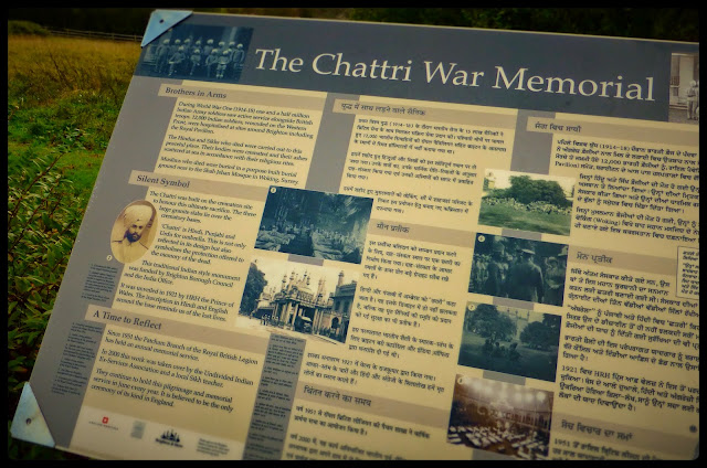
During World War One (1914-18) 1.5 million Indian Army soldiers saw active service alongside British troops. 12,000 Indian Soldiers, wounded on the Western Front were hospitalised at sites around Brighton including the Royal Pavilion.
The Hindus and Sikhs who died were carried out to this peaceful site. Their bodies were cremated and their ashes scattered at sea in accordance with their religious rites.


It felt appropriate that we should arrive at the Chattri Memorial for 11.00am where we observed a 2 minute silence. A few others arrived at the Memorial and remained still and silent also. We looked at the names of soldiers and placed poppy crosses in the grass at the base of the stone.


There were 2 coloured pieces of material tied around the pillars at the front of the Chattri.


We slowly walked out from the enclosure and discovered some cross-country cyclists entering the site. We then noticed a lone sheep in the next field, so we made valiant attempts to play border collies and round her up and reunite the flock with her... however, she was having none of our persuasive hand gestures and took off in the opposite direction from where the gate was being held open.
We gave up after it sped away following another attempt.

We continued to walk north with the assistance of a southerly wind blowing across the channel courtesy of the French. The main track was muddy, but we managed to find adequate traction from the grassy edges and eventually marched on through gates that offered alternative routes. The path we were on was the East Sussex Border Path and we would soon be joining the South Downs Way and turning in an easterly direction.

The clouds were continuing to look threatening behind us, but remained confident that we would complete the circuit without the need for waterproofs.
The pace at times was something similar to how the armed forces would have been marching across muddy fields at the start of the First World War 100 years ago.

Heads down, we battled into the wind as we turned right again off the South Down Way and after a short uphill climb we headed down the hill, passing a herd of cows that looked emotionally detached from both the environment as well as each other.
As we descended the hill and cut our way along the foot of the valley, the shelter from the forceful wind had totally dropped. It felt like a different day, however the short glimpses of blue sky had been obscured by greying clouds.

The path weaved further along as hills to both our left and right continued to offer protection from the wind. Eventually we came to a lane and turned right, passing several farm buildings. Workmen were busily constructing flint-based wall sections.

For the next 15 minutes our direction became confused as whilst the footpath sign clearly demonstrated we could turn left, which was confirmed by the OS map, there was little indication that anyone had gone this way for 10 plus years before us.


The sign on a dilapidated gate politely asked we should 'please shut the gate'... however it must have been many many years ago since it was ever closed. We hesitantly considered our options and after passing several enclosures of Partridge and maybe pheasants also, we arrived at the edge of a field, with precious little options than to navigate our way around the edge of the field and walk the remainder of the way back to the car park along the lane.


Feeling frustrated at seeing the footpath disintegrate into  impassable land, we trudged along the same lane we'd turned onto a half hour before to find several exits from which we would have emerged, had we gone a different way further up the hill.


The clouds were growing greyer and there was the first fine drizzle felt on our faces. By the time we arrived back to the cars, the rain was coming down rather more than the forecasters had proffered.
After some post walk calculations we discovered that what we thought was an excessively long walk of some 8-9 miles, turned out to have only put 7.3 miles on our milometer.